Hotels
•04 min read

La Reunion Island stands as a mystical escape, captivating travelers with its dramatic volcanic landscapes, vibrant culture, and lush tropical environments. This blog explores the unique insights offered by traditional maps versus satellite views, helping you navigate and appreciate this remarkable destination with ease. Readers will discover the key differences between a la reunion island map and its satellite view, learning how to effectively use both tools for travel planning, hiking, and understanding the island’s intricate topography.
La Reunion Island is a gem nestled in the Indian Ocean, located east of Madagascar and southwest of Mauritius. As a French overseas department, it offers an enchanting blend of European influences and tropical allure. Its volcanic origins contribute to a landscape that is both mysterious and awe-inspiring, with a tropical climate that fuels its lush vegetation and vibrant ecosystems. When searching for information on reunion island location, travelers are often struck by the island’s proximity to Madagascar and the warm oceanic currents that define its character.
The island boasts a diverse geography that ranges from towering volcanic peaks, like Piton de la Fournaise, to dense, verdant forests and stunning coastal stretches. Understanding the various reunion island regions is essential for appreciating its topography and natural beauty. Each region showcases a unique aspect of the island, whether it's the rugged highlands, scenic coastal drives, or quaint villages that reveal the island’s cultural depth.
A variety of maps cater to the diverse interests of travelers. Whether you are looking for a detailed reunion island road map to plan your drive, a specialized reunion island hiking trails map to uncover hidden paths, or a reunion island attractions map to pinpoint must-see cultural sites, these tools serve as indispensable guides. Each type of map is designed to enhance your travel experience by offering targeted information on routes, landmarks, and points of interest.
Traditional maps provide a comprehensive, detailed view of Reunion Island. They highlight roads, networks of trails, regional divisions, and the island’s overall layout. When planning a trip, these maps are invaluable for navigation and understanding elevation changes and distances. For those who enjoy exploring step by step, a map of reunion island is your go-to tool for comparing different routes and planning the most efficient itinerary.

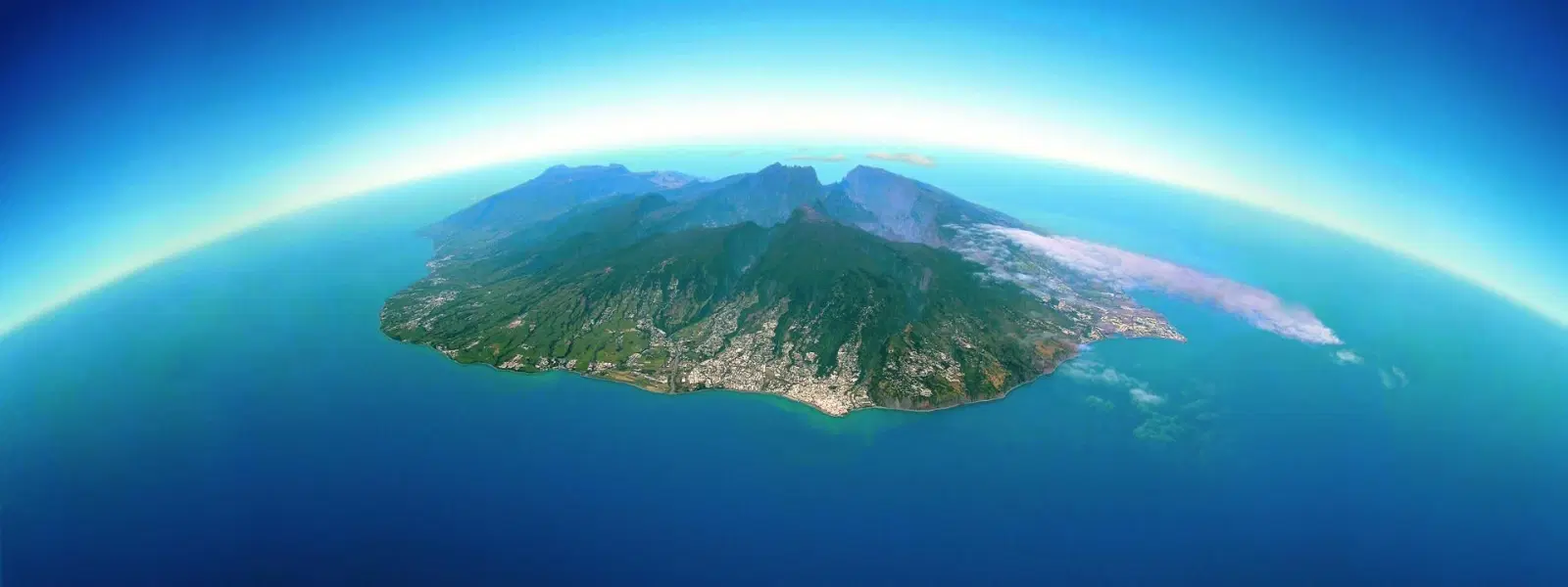
Satellite view is a digital tool that offers a bird’s-eye perspective of Reunion Island. Unlike traditional maps, satellite imagery delivers real-time, high-resolution visuals that reveal the dynamic nature of the terrain. With this technique, you can see natural formations, landmarks, and even subtle environmental changes that maps may not fully capture.
Using a reunion island satellite view empowers travelers to fully appreciate the island's topography. It not only highlights natural attractions but also uncovers lesser-known paths and hidden gems ideal for exploration. For those intent on finding the perfect hiking trail or wanting an accurate depiction of the island’s natural layout, this visual tool bridges the gap between imagination and reality, connecting you intimately with Reunion Island topography.
While traditional maps offer a detailed and structured presentation of roads, trails, and regional divisions, satellite views provide an expansive, realistic look at the landscape. Traditional maps excel in clarity and route planning, whereas satellite images deliver the raw, immersive scenery of Reunion Island. Depending on your objectives—whether navigating a busy road or exploring nature's hidden wonders—each option plays its part.
Choosing between a la reunion island map and its satellite view depends on the activity and your travel style. For instance, hikers and researchers might prefer traditional maps for planning detailed itineraries and gauging elevation changes, while travelers eager to spot unique landmarks or discover new trails would benefit from the real-time perspective of satellite views. Whether you are a wanderer, planner, professional, or luxury seeker, consider your priorities when selecting the right tool, aligning your choice with a detailed reunion island travel guide and specific needs like reunion island hiking trails.
Did you know that satellite views are ideal for identifying off-the-beaten-path hiking trails on Reunion Island, while traditional maps are better for planning routes and understanding elevation changes?
The key to maximizing your exploration of Reunion Island lies in combining both maps and satellite views. Use traditional maps to plan your journey, mark key locations, and determine the best routes. Then, switch to satellite views to get a real-time look at the terrain, weather conditions, and landscape alterations. This dual approach allows for better decision making and a richer travel experience.

Various online platforms and mobile apps offer detailed information on Reunion Island. Resources like Google Maps and specialized hiking apps provide robust features including both traditional mapping and satellite imagery. Additionally, official tourism websites often have up-to-date data and custom maps tailored for visitors. These resources make it easy to orient yourself and dive into a memorable adventure on Reunion Island.
La Reunion Island is located in the Indian Ocean, east of Madagascar and southwest of Mauritius.
La Reunion Island is a French overseas department, making it part of France.
Yes, Indians can visit Reunion Island. Visa requirements may vary, so travelers should check with the French consulate for details. Additionally, Indian travelers can benefit from knowing that direct flights from Mauritius are available, making travel more convenient.
La Reunion is famous for its volcanic landscapes, hiking trails, diverse culture, and UNESCO World Heritage sites.
In summary, traditional maps and satellite views each offer distinct and valuable insights into exploring Reunion Island. Traditional maps provide structured, detailed information essential for navigation, while satellite views deliver immersive, real-time visuals of the island’s magnificent topography. By understanding when and how to use both tools, your journey through Reunion Island becomes not just a trip but an enriched experience of discovery and wonder. Share your travel tips or experiences in the comments below to inspire fellow adventurers!
