Hotels
•04 min read

Imagine planning your dream tropical vacation, but you’re unsure where the Caribbean islands are located on the map. You're not alone—many adventurers question this region’s enigmatic geography. In this guide, we delve into the Caribbean islands’ location, exploring its diverse cultures, stunning landscapes, and rich history. Whether you’re a geography enthusiast, a seasoned traveler, or simply curious, read on to gain a clear insight and practical tips for navigating one of the world’s most vibrant regions. Where are the Caribbean islands? Let’s find out.
The Caribbean is a culturally and geographically diverse region, renowned for its sun-kissed shores and vibrant traditions. It is home to an extensive archipelago linked to the magnificent Caribbean Sea, where each island tells its own story. The region houses a mix of independent countries and territories that boast unique languages, traditions, and flavors, making it a treasure trove for any inquisitive traveler.
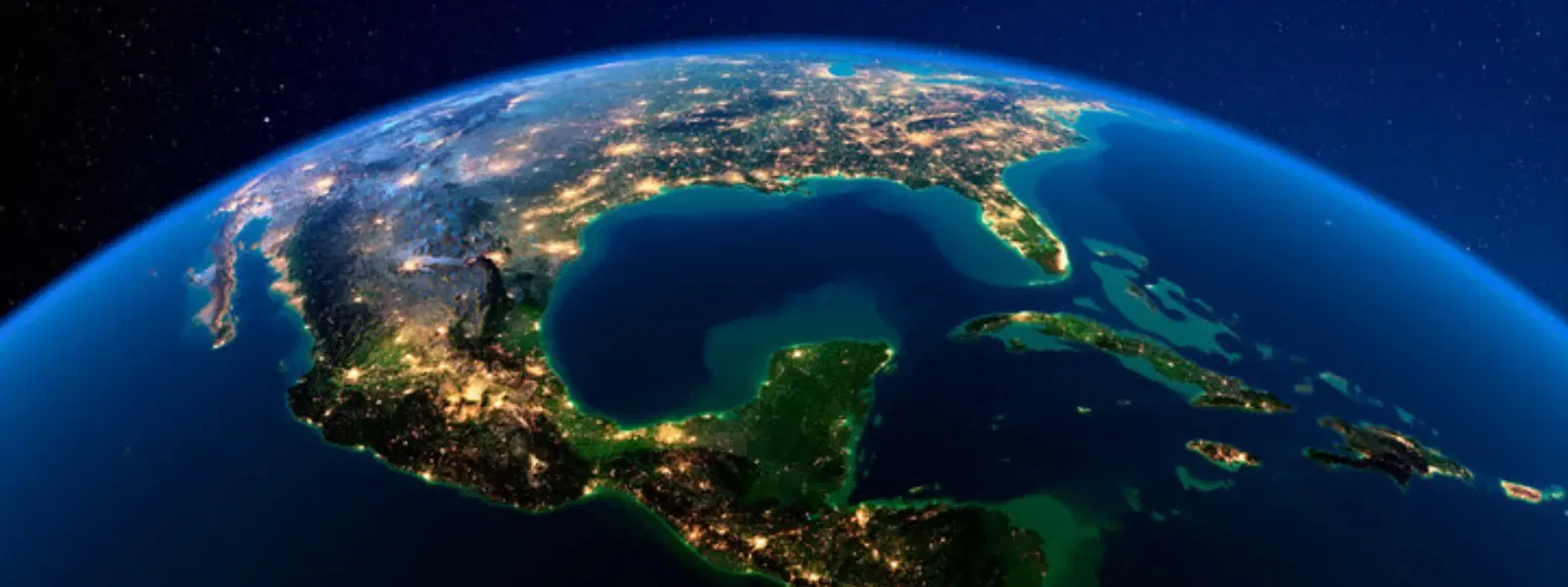
The Caribbean Sea is nestled between North America, South America, and Central America. This tropical body of water, adjacent to the vast Atlantic Ocean, creates a natural buffer that enhances the region’s serene and inviting atmosphere. Its strategic position has historically made it a crossroads for trade and cultural exchange.
Locating the Caribbean islands on a map may seem challenging at first, but with a few clear pointers, it becomes a fun puzzle. Start by identifying the Gulf of Mexico to the northwest and the Atlantic Ocean to the east. Trace the curved coastline, and you'll spot a collection of islands scattered across the turquoise waters. Their tropical climate, marked by vivid hues and lush landscapes, is a result of their proximity to the equator.
The Caribbean archipelago is divided into three primary groups: the Greater Antilles, the Lesser Antilles, and the Bahamas. The Greater Antilles include larger islands renowned for their cultural landmarks and natural beauty, while the Lesser Antilles are dotted with smaller, picturesque islands. The Bahamas, with its crystal clear waters, provide a unique, island-hopping experience distinct from the other clusters.
The region is a mosaic of independent nations and special territories. Notable countries include Cuba, Jamaica, Haiti, the Dominican Republic, and Barbados, among others. Some islands, like Puerto Rico and the U.S. Virgin Islands, are territories, while others enjoy full sovereignty. This blend of governance adds to the region’s fascinating political and cultural tapestry.

When looking at the Caribbean islands’ geography, several names stand out. Cuba tops the list with its expansive landmass and storied history. Hispaniola, which is home to Haiti and the Dominican Republic, follows suit, along with Jamaica, Puerto Rico, and Trinidad. Their impressive sizes not only underscore their natural significance but also their role as cultural and economic hubs in the region.
The Caribbean region is home to over 7,000 islands, islets, and cays. While only a small percentage are inhabited, each island—whether bustling with activity or untouched by modern life—adds to the region’s mystique. According to widely recognized data, only about 2% of these islands are inhabited, leaving the rest as pristine natural havens.
For many Indian travelers, the Caribbean represents an alluring getaway. Destinations such as the Bahamas, Aruba, St. Lucia, and the Dominican Republic are famed for their scenic beaches, lively music, and cultural festivals. These spots are renowned not only for their stunning natural beauty but also for offering experiences that cater to a variety of traveler profiles, from budget wanderers to family planners. Indian tour operators often feature packages for these destinations, making them accessible and convenient for travelers from India.
Whether you're planning a solo adventure or a family vacation, having the right maps at your fingertips is essential. Use physical maps to get a sense of the geography, and complement that with digital tools like specialized digital mapping tools or travel guides for the Caribbean. These resources not only help you pinpoint where the Caribbean islands are but also guide you to hidden gems within the archipelago. Breaking down your itinerary into smaller segments can help make the planning process smoother and more enjoyable.
The Caribbean region is home to over 7,000 islands, islets, and cays, yet only about 2% of these islands are inhabited. The rest remain untouched, offering a glimpse into pristine natural beauty.
The Caribbean has long been a crossroads of cultures, playing a significant role in global trade, colonization, and migration. Its strategic location made it a key player in the era of exploration, with various empires vying for influence. This rich historical backdrop is evident in the region’s diverse cultural expressions—from its music and cuisine to its vibrant festivals.

Geography has a profound influence on culture, and the Caribbean is no exception. The natural separation of islands led to the development of unique traditions and dialects. The mixing of African, European, Indigenous, and Asian influences has created a dynamic cultural landscape that continues to evolve, enriching the experiences of visitors from across the globe.
The Caribbean islands are located in the Caribbean Sea, bordered by North America, South America, and Central America.
Some Caribbean islands, such as Puerto Rico and the U.S. Virgin Islands, are territories of the USA, while most are independent nations or territories of other countries.
Countries in the Caribbean include Cuba, Jamaica, Haiti, the Dominican Republic, Barbados, Trinidad and Tobago, among others.
The top three largest islands in the Caribbean are Cuba, Hispaniola, and Jamaica.
There are over 7,000 islands, islets, and cays in the Caribbean region.
The Caribbean islands are a wonderfully diverse region, both geographically and culturally. By understanding where the Caribbean islands are located and learning about their major groups, historical significance, and cultural tapestry, you can gain deeper insights into this tropical paradise. Whether your journey is fueled by adventure, study, or a quest for relaxation, a well-planned exploration of the Caribbean promises to broaden your horizons and inspire future travel dreams. What destinations are on your radar for your next Caribbean adventure?
